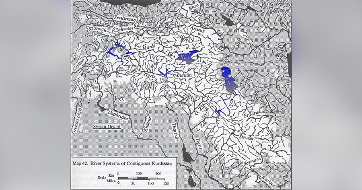
In an otherwise water-starved region, Kurdistan is blessed with abundant precipitation. The generous regime has made Kurdistan one of the few watersheds of the Middle East. Rivers like the Tigris, Euphrates, Khabur, Tharthar, Ceyhan, Araxes, Kura, Safidrud, Karkha, and their major tributaries spring from the mountains of Kurdistan. Those rivers that are entirely or nearly entirely in Kurdistan are usually of historical importance to the Kurds. Among these are the Murat (Arasân) and Buhtân rivers in northern and western Kurdistan (in Turkey); the Peshkhâbur, the Lesser and the Greater Zâb, and the Sirwân/Diyâla in central Kurdistan (in Iraq); and the Jaghatu (Zarrinarud), the Tâtâ'u (Siminarud), the Zohâb (Zahâb), and the Gâmâsiyâb in southern Kurdistan (in Iran) (Map 42).
The wealth of glacial and snow fields as well as the favorable geological properties of the land produce what is a common feature in most areas of Kurdistan (except in the volcanic north): exceptionally powerful springs. Sarâb Ghambar in southern Kurdistan, for example, emerges from the ground already a bona fide river, with a capacity of 650 gallons per second. The river flows over 400 miles to the Persian Gulf and is the source water of the Saymara-Karkha river system. The preponderance of Kurdish towns and villages with the prefix Sarâb or Kâni (spring in Kurdish) in their names commemorates this bounty of springs. While the Kurdish rivers are the lifeblood of the lowland Middle Eastern economies, it is the springs that serve as the main source of artificial irrigation and domestic water for the Kurds. The largest Kurdish city, Kirmânshâh, collects its tap water exclusively from the spring fields around the city.
The regulation of the flow of river waters is more for the benefit of the non-Kurdish users on the lowlands than the Kurds of the mountains. As such, many hydraulic projects now dot Kurdish watercourses, and many more projected.
The most important of these are in the Tigris-Euphrates catchment area. In central Kurdistan, two large dams at Darbandi Khân (on the Sirwân-Diyâla) and Dokhân (or Dokkân on the Lesser Zâb) double as major hydroelectric sources for the Baghdad metropolitan region. In northern and western Kurdistan in Turkey, the multi-billiondollar Southeast Anatolian Project (GAP, from its Turkish acronym) envisions damming the Tigris, the Euphrates, and their tributaries to provide regulated water for irrigation of the parched lowland plains and to provide inexpensive electricity for domestic and industrial use. The water is also seen as a cash commodity, for it is to be sold through the so-called peace pipeline, which is projected to run 1,700 miles from Turkey to the thirsty countries of the Middle East, as far south as Kuwait and Saudi Arabia (Gregory 1991). The source water for the pipeline is to be the Ceyhan-Seyhan river system in the eastcentral Taurus mountains. It is doubtful that these rivers could provide the necessary resources for the the project, and the Euphrates basin may eventually become the main supplier for this export scheme.
Many of the dams have already been completed, including the mammoth Ataturk Dam on the Euphrates near Urfa, which is by far the largest in the GAP and the fifth largest in the world. When complete, the GAP will consist of 13 major hydroelectric and irrigation projects (seven in the Euphrates basin, six in the Tigris). GAP envisions irrigating over 4 million acres of land and producing 24 megawatt-hours of electricity per year. The fact that in the 40 years prior to the GAP the state brought only 1.4 million acres of land under artificial irrigation in all of Turkey, and produced only 34 megawatt-hours of electricity nationwide in 1985, might highlight the importance of GAP.
The filling of the AtatUrk Dam reservoir in 1990, with its final capacity exceeding the total annual discharge of the Euphrates, or even the Nile, showed the importance of Kurdish waters for other economies down on the plains as well (Table 7). Turkey all but halted the flow of the Euphrates into Syria and Iraq, to whom the river is of vital national economic importance, for two months. The swift mobilization of the Syrian armed forces (Angus 1989) and the threats and counter-threats flying between Ankara, Damascus, and Baghdad vividly demonstrate the strategic importance of water in the Middle East, and Kurdistan as one of its most important sources.
TABLE 7. DAMS PRESENTLY UNDER CONSTRUCTION OR RECENTLY COMPLETED IN WESTERN AND NORTHERN KURDISTAN IN ANATOLIA.
| Dam | River | Province | Capacity | Electricity | Irrigation |
| (Billion ft) | (Megawatts) | Acreage | |||
| Dumluca | Bugur | Mardin | 12 | 0 | 6,000 |
| Göksu | Göksu | Diyarbakir | 56 | 0 | 9,000 |
| Memze1et | Ceyhan | K. Maras | 256 | 120 | 116,000 |
| Atattirk | Euphrates | Urfa | 2,535 | 2,400 | 2,175,000 |
| Hacihidir | Hacihidir | Urfa | 42 | 0 | 8,500 |
| Kiralkizi | Tigris | Diyarbakir | 449 | 90 | n.a. |
| Kuzgun | Serceme | Erzurum | 83 | 20 | 130,000 |
| Polâr | Polâr | Malatya | 63 | 0 | 7,000 |
| Ozluce | Perisuyu | Elazig | 228 | 160 | 0 |
| Patnos | Gevi | Agri | 82 | 0 | 12,500 |
Figures have been rounded.
Source: Statistical Yearbook of Turkey, 1989.
Due to the extraordinary archaeological richness of the land, almost any dam built in Kurdistan drowns a portion of Kurdish history. The most glaring loss was the drowning of the entire historic city of Samsat (ancient Samosata) behind the Ataturk Dam. In only a few cases, such as the site of the Keban Dam at the confluence of Murat and Euphrates Rivers in northwestern Kurdistan in Turkey, have any pre-flooding archaeological excavations been made. One can only guess the magnitude of the loss of the historical remains in sites like the Darbandi Khân Dam near Halabja in Iraq-the very historic heartland of Kurdistan, where more ancient mounds per square mile are known to exist than in the rich Mesopotamian plain. Vast archaeological wealth has thus been lost forever by flooding the very same mountain valleys where civilization in Kurdistan first took root nearly 11,000 years ago.
Many natural lakes of various sizes, most with great potential for tourism, can be found in Kurdistan. Lake Zarivar near Marivan in eastern Kurdistan, surrounded by forested mountains and attractive shores, is just one of these sites. Lake Vân in northern Kurdistan is the world's fourth largest non-saline body of water by volume. The lake's surrounding country, rich with archaeological and architectural monuments, is an ideal tourist spot, well suited for commercial development. Fifteen miles west of the shores of Lake Vân is the crescent-shaped Lake Nimrod, formed at the bottom of Mt. Nimrod (called Nimrut Dagli on Turkish maps, but not to be confused with the archaelogical site of Nimrut Dag in far western Kurdistan, north of Adiyaman), a volcanic caldera 8 miles in diameter and surrounded by vertical cliffs half a mile high. The lake ranks among the most attractive natural sites in all of Kurdistan.
Further Readings and Bibliography: Doomed by the Dam: A Survey of the Monuments Threatened by the Creation of the Keban Dam Flood Area, Faculty of Architecture, Publ. No. 9 (Ankara: Middle East Technical University, 1967); Robert Whallon, An Archaeological Survey of the Keban Reservoir Area of East-Central Turkey, Memoirs of the Museum of Anthropology, No. 11 (Ann Arbor: University of Michigan Press, 1979); Daniel Stoll and Joyce Starr, eds., The Politics of Scarcity: Water in the Middle East (Boulder: Westview, 1988); Joyce Starr and Daniel Stoll, U.S. Foreign Policy on Water Resources in the Middle East (Washington: The Center for Strategic and International Studies, 1987); John Kolars and H. Mitchell, The Euphrates River (Carbondale: University of Illinois Press, 1990); Thomas Naff and Ruth Matson, eds., Water in the Middle East: Conflict or Cooperation? (Boulder: Westview, 1984); Thomas Naff, "Water: An Emerging Issue in the Middle East?" The Annals of the American Academy of Political Scientists (November 1985); "Middle East: Water Issues in the 1990's," testimonies submitted to the U.S. House [of Congress] Subcommittee on Europe and the Middle East, Washington, June 26, 1990; Joseph R. Gregory. "Liquid Asset," World Monitor 28 (November 1991); Joyce Starr, "Water Wars," Foreign Policy 82 (Spring 1991). Angus Hindley, "Battle Lines Drawn for Euphrates," Middle East Economic Development (October 13, 1989).
Sources: The Kurds, A Concise Handbook, By Dr. Mehrdad R. Izady, Dep. of Near Easter Languages and Civilazation Harvard University, USA, 1992